
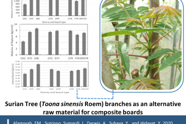
Aboveground Biomass and Carbon Stock Estimation Using UAV Photogrammetry in Indonesian Mangroves and Other Competing Land Uses
Dr. Elham Sumarga and his colleagues report a novel application using unmanned aerial vehicles (UAVs) to estimate and compare aboveground biomass (AGB) carbon stocks of mangrove forests with two alternate replacement commercial land uses (oil palm and coconut plantations) in Lubuk Kertang and Pulau Sembilan, North Sumatra, Indonesia. They generated high-accuracy digital surface models (DSMs) and digital terrain models (DTMs), as well as elevation data from a global navigation satellite system (GNSS). Through analysis, they highlight how mangrove forest conversion to oil palm and coconut plantations significantly decreases the aboveground biomass carbon (AGB) and carbon stocks (AGC) of selected mangrove ecosystems in Indonesia. This combined methodological approach may be a useful tool to assist with blue carbon inventories as well as for selecting specific mangrove conservation and restoration areas across larger spatial scales.
Article Citation:
Basyuni, M., Wirasatriya, A., Iryanthony, S. B., Amelia, R., Slamet, B., Sulistiyono, N., Pribadi, R., Sumarga, E., Eddy, S., Al Mustaniroh, S. S., Sasmito, S. D., Sidik, F., Kajita, T., Ali, H. M., Macklin, P. A., Arifanti, V. B. (2023). Aboveground biomass and carbon stock estimation using UAV photogrammetry in Indonesian mangroves and other competing land uses. Ecological Informatics, 77, 102227. https://doi.org/10.1016/j.ecoinf.2023.102227.
Image:
Dr. Elham Sumarga Profile Picture
(Source: https://sith.itb.ac.id/en/dr-elham-sumarga-3/)
Ecological Informatics Cover
(Source: https://www.sciencedirect.com/journal/ecological-informatics)
https://www.canva.com/

